![](/images/other/stat-length.png)
![Tocht Te voet La Boissière - La Boissière Chapelle VALCROSE Puech BARTELIE - Photo](https://media.geolcdn.com/t/1900/400/ext.pjpeg?maxdim=2&url=https%3A%2F%2Fstatic1.geolcdn.com%2Fsiteimages%2Fupload%2Ffiles%2F1545311037marcheuse_200dpi.jpg)
La Boissière Chapelle VALCROSE Puech BARTELIE
JEANJOSY
Gebruiker
![Lengte](/images/other/stat-length.png)
Lengte
14,9 km
![Max. hoogte](https://static1.geolcdn.com/siteimages/upload/files/1508320355ic_sort_altitude_max_24dp.png)
Max. hoogte
368 m
![Positief hoogteverschil](https://static1.geolcdn.com/siteimages/upload/files/1508320355ic_sort_den_pos_24dp.png)
Positief hoogteverschil
326 m
![Km-Effort](/images/other/stat-length.png)
Km-Effort
19,3 km
![Min. hoogte](https://static1.geolcdn.com/siteimages/upload/files/1508320355ic_sort_altitude_min_24dp.png)
Min. hoogte
114 m
![Negatief hoogteverschil](https://static1.geolcdn.com/siteimages/upload/files/1508320355ic_sort_den_neg_24dp.png)
Negatief hoogteverschil
331 m
![Boucle](https://static1.geolcdn.com/siteimages/upload/files/16400158638029165_repeat_loop_refresh_sync_direction_icon.png)
Boucle
Ja
Datum van aanmaak :
2023-03-09 16:16:07.731
Laatste wijziging :
2023-03-09 16:26:40.619
![Te voet](https://static1.geolcdn.com/sitytour/trail-icons/100.png)
4h22
Moeilijkheid : Gemakkelijk
![Scan deze QR-code om de tocht te openen in de SityTrail-applicatie](https://capi.geolives.com/qq0zvz2zws4bq2lad0pu/sitytour/trails/3579140/qr.png?size=200)
Gratisgps-wandelapplicatie
Over ons
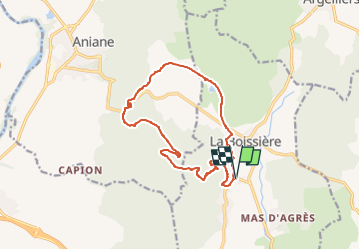
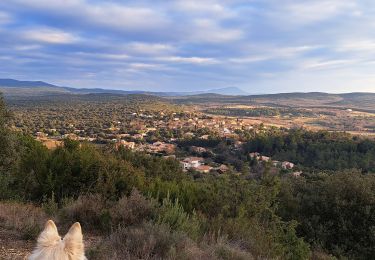
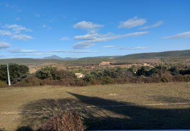
Tocht Te voet van 14,9 km beschikbaar op Occitanië, Hérault, La Boissière. Deze tocht wordt voorgesteld door JEANJOSY.
Beschrijving
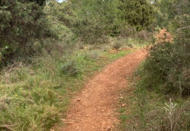
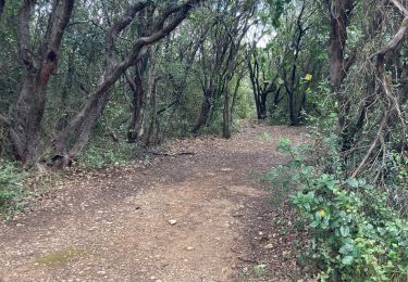
Balade assez facile en empruntant une ancienne voie ferrée et des chemins empirrés.
Peu de sentier à la queue leu-leu.
Plaatsbepaling
Land:
France
Regio :
Occitanië
Departement/Provincie :
Hérault
Gemeente :
La Boissière
Locatie:
Unknown
Vertrek:(Dec)
Vertrek:(UTM)
551675 ; 4833688 (31T) N.
Opmerkingen
Wandeltochten in de omgeving
![Tocht Stappen Aniane - Aniane ruisseau des Corbières - Photo](https://media.geolcdn.com/t/375/260/ext.jpg?maxdim=2&url=https%3A%2F%2Fservices.sitytrail.com%2FGeolivesWS%2FDownloadMedia.ashx%3FTrailID%3D371677%26Media%3D20141221154017.jpg)
![Stappen Stappen](https://static1.geolcdn.com/sitytour/trail-icons/101.png)
Aniane ruisseau des Corbières
Stappen
Gemakkelijk
(3)
Aniane,
Occitanië,
Hérault,
France
![](/images/other/stat-length.png)
9,5 km | 12 km-effort
2h 34min
![](https://static1.geolcdn.com/siteimages/upload/files/16400158638029165_repeat_loop_refresh_sync_direction_icon.png)
Ja
![Tocht Stappen Argelliers - 2023-01-03_14h52m32_Le Roc de Pampelune et son oppidum et le Dolmen A du Mas Reynard - Photo](https://media.geolcdn.com/t/375/260/ext.jpg?maxdim=2&url=https%3A%2F%2Fstatic1.geolcdn.com%2Fsiteimages%2Fupload%2Ffiles%2F1553511878bg_sport_marche.png)
![Stappen Stappen](https://static1.geolcdn.com/sitytour/trail-icons/101.png)
2023-01-03_14h52m32_Le Roc de Pampelune et son oppidum et le Dolmen A du Mas ...
Stappen
Zeer moeilijk
(1)
Argelliers,
Occitanië,
Hérault,
France
![](/images/other/stat-length.png)
21 km | 28 km-effort
6h 25min
![](https://static1.geolcdn.com/siteimages/upload/files/16400158638029165_repeat_loop_refresh_sync_direction_icon.png)
Ja
![Tocht Stappen La Boissière - 2024-11-05_19h16m17_autour-de-la-boissiere- - Photo](https://media.geolcdn.com/t/375/260/ext.jpg?maxdim=2&url=https%3A%2F%2Fstatic1.geolcdn.com%2Fsiteimages%2Fupload%2Ffiles%2F1553511878bg_sport_marche.png)
![Stappen Stappen](https://static1.geolcdn.com/sitytour/trail-icons/101.png)
2024-11-05_19h16m17_autour-de-la-boissiere-
Stappen
Moeilijk
(1)
La Boissière,
Occitanië,
Hérault,
France
![](/images/other/stat-length.png)
13,2 km | 17,1 km-effort
3h 52min
![](https://static1.geolcdn.com/siteimages/upload/files/16400158638029165_repeat_loop_refresh_sync_direction_icon.png)
Ja
![Tocht Noords wandelen Montarnaud - Grand tour - Photo](https://media.geolcdn.com/t/375/260/cc75d9d1-51d1-4e54-babf-5f4c47c675db.jpg&format=jpg&maxdim=2)
![Noords wandelen Noords wandelen](https://static1.geolcdn.com/sitytour/trail-icons/102.png)
Grand tour
Noords wandelen
Moeilijk
Montarnaud,
Occitanië,
Hérault,
France
![](/images/other/stat-length.png)
16,1 km | 21 km-effort
3h 0min
![](https://static1.geolcdn.com/siteimages/upload/files/16400158638029165_repeat_loop_refresh_sync_direction_icon.png)
Ja
![Tocht Noords wandelen Montarnaud - MONTARNAUD - Photo](https://media.geolcdn.com/t/375/260/2d3a94d9-b964-4396-9182-7dd3909b4b69.jpg&format=jpg&maxdim=2)
![Noords wandelen Noords wandelen](https://static1.geolcdn.com/sitytour/trail-icons/102.png)
MONTARNAUD
Noords wandelen
Gemakkelijk
Montarnaud,
Occitanië,
Hérault,
France
![](/images/other/stat-length.png)
7,6 km | 10,2 km-effort
1h 41min
![](https://static1.geolcdn.com/siteimages/upload/files/16400158638029165_repeat_loop_refresh_sync_direction_icon.png)
Ja
![Tocht Stappen La Boissière - Boucle de la Boisière - Photo](https://media.geolcdn.com/t/375/260/ab76a747-c943-4dc2-866e-a48a444bac2c.jpg&format=jpg&maxdim=2)
![Stappen Stappen](https://static1.geolcdn.com/sitytour/trail-icons/101.png)
Boucle de la Boisière
Stappen
Zeer moeilijk
La Boissière,
Occitanië,
Hérault,
France
![](/images/other/stat-length.png)
14,7 km | 21 km-effort
4h 7min
![](https://static1.geolcdn.com/siteimages/upload/files/16400158638029165_repeat_loop_refresh_sync_direction_icon.png)
Ja
![Tocht Stappen Saint-Paul-et-Valmalle - 2023-01-15_18h33m54_Massifs et vallées au Sud de Saint-Paul-et-Valmalle - Photo](https://media.geolcdn.com/t/375/260/ext.jpg?maxdim=2&url=https%3A%2F%2Fstatic1.geolcdn.com%2Fsiteimages%2Fupload%2Ffiles%2F1553511878bg_sport_marche.png)
![Stappen Stappen](https://static1.geolcdn.com/sitytour/trail-icons/101.png)
2023-01-15_18h33m54_Massifs et vallées au Sud de Saint-Paul-et-Valmalle
Stappen
Zeer moeilijk
(1)
Saint-Paul-et-Valmalle,
Occitanië,
Hérault,
France
![](/images/other/stat-length.png)
16,7 km | 23 km-effort
5h 22min
![](https://static1.geolcdn.com/siteimages/upload/files/16400158638029165_repeat_loop_refresh_sync_direction_icon.png)
Ja
![Tocht Stappen Argelliers - 2022-12-29_14h51m49_Les Dolmens de Vailhauquès - Photo](https://media.geolcdn.com/t/375/260/ext.jpg?maxdim=2&url=https%3A%2F%2Fstatic1.geolcdn.com%2Fsiteimages%2Fupload%2Ffiles%2F1553511878bg_sport_marche.png)
![Stappen Stappen](https://static1.geolcdn.com/sitytour/trail-icons/101.png)
2022-12-29_14h51m49_Les Dolmens de Vailhauquès
Stappen
Moeilijk
(3)
Argelliers,
Occitanië,
Hérault,
France
![](/images/other/stat-length.png)
9,4 km | 12,3 km-effort
2h 47min
![](https://static1.geolcdn.com/siteimages/upload/files/16400158638029165_repeat_loop_refresh_sync_direction_icon.png)
Ja
![Tocht Stappen Argelliers - Arsel Argelliers Montarnaud - Photo](https://media.geolcdn.com/t/375/260/f29931cb-207b-4689-a4f5-5240bd009557.jpg&format=jpg&maxdim=2)
![Stappen Stappen](https://static1.geolcdn.com/sitytour/trail-icons/101.png)
Arsel Argelliers Montarnaud
Stappen
Heel gemakkelijk
Argelliers,
Occitanië,
Hérault,
France
![](/images/other/stat-length.png)
19,7 km | 24 km-effort
4h 20min
![](https://static1.geolcdn.com/siteimages/upload/files/16400158638029165_repeat_loop_refresh_sync_direction_icon.png)
Ja